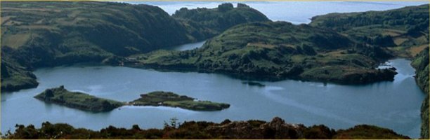
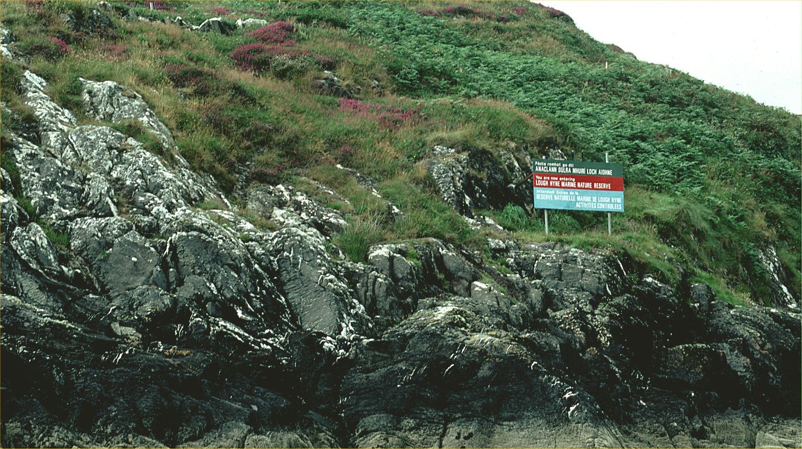
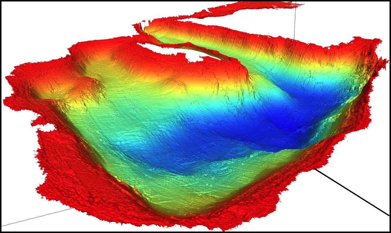
Lough Hyne (also known as Lough Ine) is a sheltered sea-lough in west Cork on the south west coast of Ireland, declared a nature reserve since 3rd June 1981 under section 15 of the Wildlife Act 1976. It was the first statutory Marine Nature Reserve in Europe, and is a Special Area of Conservation, Natural Heritage Area, and an Irish Biogenetic Reserve, set up under the auspices of the Council of Europe. This marine lake lies on a NNW-SSE axis, ~1 km long and ~0.75km wide, divided unequally into north and south basins by Labhra Island. The deepest area of ~50m is to its west forming the Western Trough, but it is only ~1m at low water directly to the east of the Island. To the south-east of the Lough, there is a narrow and shallow channel ~1.2km long. At its narrowest (20m, depth ~1m at low water), a tidal Rapids is formed over a sill of bedrock. This connects through Southern’s Bay and Barloge Creek out to the Atlantic Ocean, at Carrigathorna to the west (Kitching & Ebling, 1967). at Bullock Island to the east, and through The Coosh at high water (a bank of gravel and large stones). There is a 97m long cave from this channel into Bullock Island. The origin of Lough Hyne is thought to be due to glacial erosion. The initial marine transgression was during Neolithic times, through the Rapids area (Holland, 1988). There is a good description of the geology of the area in this publication.
There are good general descriptions of Lough Hyne in Kitching (1987b, c) and Myers et al., 1991. One of the earliest was by the great naturalist Robert Lloyd Praeger (Praeger, 1937): ‘...the clear sheltered lake...resembles a gigantic marine aquarium... Many forms common on the surrounding shores are absent or very rare in the lough...On the other hand, many animals and some plants grow to quite unusual dimensions. The fauna is characterized by a remarkable abundance and variety of species....To lean over the side of a boat and view the bottom with a ‘water-telescope’ is like peeping into a strange calcareous sort of fairyland’. Lough Hyne has a wide variety of habitats, from bedrock to sand; cliffs (littoral and sublittoral), gravel, boulders, and depths ranging to 50m. Special habitats include eelgrass beds in Barloge Creek, and current swept kelps in the Rapids. There is an early, full description of the fauna and flora of Lough Hyne in Renouf (1931), with further detailed summaries in Myers et al. (1991).
The catchment about Lough Hyne is small due to high surrounding land, and freshwater inputs are small, being mainly due to streams at the north-east corner, West Quay and the western corner of the Goleen. Salinity, as a result, remains close to that of the open sea, with a continual and periodic selective exchange with coastal water passing via the Rapids. Occasional heavy rain draining into the Lough results in a layer of freshwater over the salt water, lowering shallow water salinity to as little as 30%o, but there is no significant difference in bottom water salinity (Kitching et al., 1952; Minchin 1992c).
Temperatures vary between 4oC and 21oC during the year, with the highest temperatures being in August, and can reach 25oC in that month in the shallow waters of the Goleen (Kitching & Ebling, 1967; pers. comm. D. Minchin). During the summer, inflow brings in cooler water from the open sea over the Rapids, but there is no effect in areas like Codium Bay, which are largely influenced by surface water temperatures in the main Lough. (Kitching et al., 1952). During warm summer periods, deoxygenation below c. 25m takes place in the Western Trough, the depth of the hypolimnion varying according to meteorological conditions (Bassindale et al., 1957); these conditions normally result in the mortality of all the fauna living below that depth.
There is limited wave-action, due to a short fetch, and shelter by the high surrounding land, with waves rarely exceeding 30cm in the Lough. Tides in the Lough are asymmetric in rhythm, due to the delay caused by the presence of the Sill [Rapids], with an inflow of 4 hours and ebb of 8.5 hours. Tidal heights inside the Lough vary by 0.7-1.0m (Kitching & Ebling, 1967). Currents over the Rapids approach 3m/sec., but are negligible over much of the Western Trough and North Basin. Currents do not exceed 0.5 cm/sec in Barloge Creek (Kitching et al., 1952).
Within the reserve area, there is a wide variation of wave-exposure, current speed, depth, light penetration and siltation. Substrata range from vertical cliffs of bedrock, boulder slopes to fine sediments. Lough Hyne is generally accessible and small enough to sample.
Copyright © Julia Nunn